Aggregate Industries' last planning application was all about separating fact from fiction. The new application will no doubt be much the same. Perhaps that’s not surprising, in this new "post-truth" age in which we find ourselves.
AI will wheel out its expert reports again, but read I'm a Scientist, and I Don't Believe in Fact from Julia Shaw, author of "The Memory Illusion: Remembering, Forgetting, and the Science of False Memory". She reminds us that "scientists don’t prove anything". In fact:
... please stop saying "because, science" to justify your argument, and using “FACT” as a preface to your statements. These are just the grown-up versions of "because I said so." We need to remind each other to stay on our toes and to actually backup our claims.
And this applies to AI’s water consultants, Amec Foster Wheeler, too.
There is uncertainty with any data, and any prediction derived from that data. No model can make predictions with 100% certainty. Scientists start their academic life having that drummed into them, and know to give an indication of confidence in any results they produce.
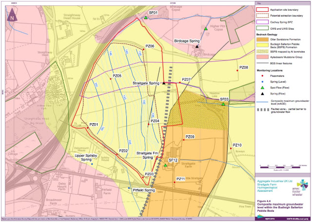
Amec used just 6 numbers (from PZ01 to PZ06) to map maximum groundwater contours across more than 60 acres at Straitgate Farm; contours that "represent just two of the many possible interpretations of the data which themselves are based on an incomplete parameterization of the detailed groundwater dynamics of the site".
Does it sound like Amec is 100% confident in those contours to you? It is these contours that AI wants to quarry down to, without leaving 1m above the maximum water table to protect drinking water supplies.
If Amec is not 100% confident in those contours - and how can it be - then how confident is it? How does that translate to a +/- figure? If it's no more precise than +/- 1m, say, how can AI justify not leaving the 1m? If it's more precise, then Amec needs to actually back up its claims.
Last year, we asked DCC:
Since AI now intends to dig right down to the maximum water table, perhaps you could ask Amec to confirm the specific level of accuracy (in +/- m) to which their maximum groundwater contours are mapped?
DCC asked AI and Amec for an answer. To date, none has been forthcoming.